Hurricanes in Louisiana
When is Hurricane Season in Louisiana?
The official hurricane season in Louisiana coincides with the Atlantic hurricane season, beginning on June 1 and ending on November 30 each year. Louisiana is among the states most frequently impacted by hurricanes in the United States. Historical data indicates that Louisiana has been hit by a tropical storm or major hurricane 54 times since 1851, a number only surpassed by Florida.
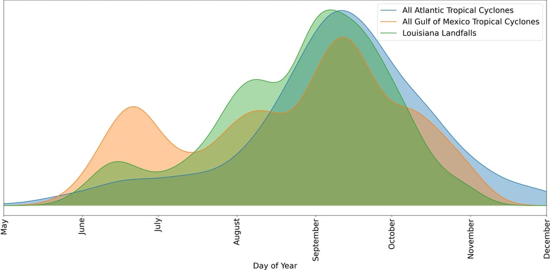
As seen in the graph above, the probability of hurricane occurrence in Louisiana aligns with the trends observed in the Atlantic basin and Gulf-originated storms. The data, which is obtained from the NOAA Hurricane Research division, demonstrates a noticeable increase in tropical storm activity in June, followed by a peak in September. This June spike is typical of storms originating from the Gulf of Mexico.
The Gulf of Mexico's propensity for generating early storms can be attributed to its warm waters, which can foster the development of a tropical depression. A prime example of a Gulf-originated storm is Hurricane Audrey, which made landfall between Sabine Pass and Johnsons Bayou, Louisiana, around 7 AM CST on June 27, 1957, as a strong category three hurricane. More information on the phenomenon of early Gulf storms can be found in a publication by Texas A&M.
Where do Hurricanes Hit the Most in Louisiana?
In Louisiana, the regions along the coast, such as the parishes of Terrebonne, Lafourche, Jefferson and Plaquemines are frequently hit due to their direct exposure to the Gulf of Mexico. These areas are especially susceptible to hurricanes, often experiencing devastating storm surges and hurricane-force winds.
According to the National Weather Service, inland regions such as Baton Rouge and New Orleans also experience significant hurricane impacts. Their low-lying topography makes them susceptible to floods caused by torrential rain and storm surges.
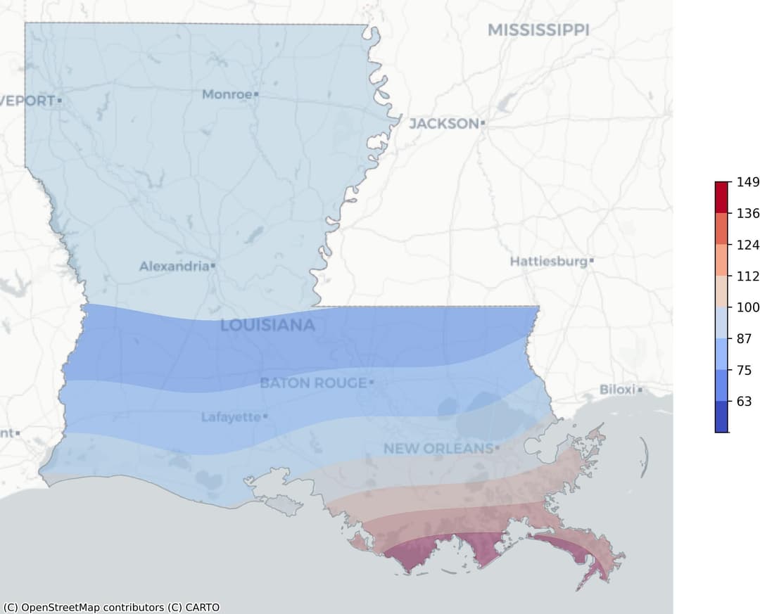
The heatmap above provides a visual representation of hurricane risk patterns based on the frequency of occurrences and weighted by wind speed. The map, color-coded from blue to red, shows that the coastal regions are at the highest risk.
The red zone, indicating a higher frequency of hurricanes and stronger wind speeds, is heavily concentrated along the coastline, particularly around the aforementioned parishes. Moving inland, the risk gradually decreases with the color fading to blue, indicating fewer hurricanes and lower wind speeds.
This gradient illustrates the geographical distribution of hurricane risk in Louisiana, underscoring the increased vulnerability of coastal regions to these powerful natural disasters.
Note: The Louisiana barrier island shoreline is eroding at a rate, in some places, exceeding 20 meters per year as a result of both hurricanes and normal processes, according to the US Geological Survey. This erosion further exacerbates the vulnerability of the coastal regions to hurricane impacts.
What Are The Recent Hurricanes in Louisiana?
Hurricane Ida (2021): Ida caused immense damage and loss of life, primarily in southeastern Louisiana. It's estimated that Ida caused approximately $55 billion in damages in Louisiana. The hurricane damaged thousands of buildings, particularly in the coastal portions of Lafourche and Jefferson Parishes, where almost every structure was damaged. Ida was also responsible for 28 deaths along the Gulf Coast, including 26 in Louisiana.
Hurricane Laura (2020): Laura was a devastating hurricane for southwestern Louisiana. It caused 34 indirect deaths in the United States, 26 in Louisiana, and 8 in Texas. Laura’s winds and surge severely damaged or destroyed numerous homes and other structures in that part of the state, especially from the areas around Cameron through Lake Charles.
Hurricane Delta (2020): Delta caused around $2.9 billion in damages in the U.S. Damage was mostly confined to Louisiana, which was affected by Hurricane Laura a little over a month prior. In southwestern Louisiana, Delta caused additional damage to homes and businesses. The most significant damage from Delta in Louisiana was due to widespread flooding, especially across the central portions of the state.
Hurricane Zeta (2020): Zeta caused widespread damage across southeastern Louisiana near and east of the track of Zeta’s center. Hundreds of homes in Orleans, Jefferson, St. Bernard, Plaquemines, Terrebonne, and Lafourche Parishes suffered significant wind damage, with numerous reports of lost or severely damaged roofs, and about 100 homes were destroyed.
Hurricane Gustav (2008): Gustav caused considerable casualties and damages along its track. The storm caused $210 million in damages in Jamaica. In Louisiana, significant property damages occurred, although exact monetary damage figures are not available.
Hurricane Katrina (2005): Katrina was an extraordinarily powerful and deadly hurricane that inflicted large loss of life and catastrophic damage. It was the costliest and one of the five deadliest hurricanes to ever strike the United States. According to louisiana.gov Hurricane Katrina was responsible for the death of up to 1,170 persons in Louisiana. It left about three million people without electricity, some for several weeks. The hurricane severely impacted or destroyed workplaces in New Orleans and other heavily populated areas of the northern Gulf Coast.
Hurricane Rita (2005): Rita caused substantial flood damage in portions of the Lake Charles area, including downtown and some surrounding residential communities. Storm surge damage to homes and businesses in low-lying areas extended eastward along the entire coast of Louisiana, although the impact in the New Orleans area was not nearly as widespread as during Hurricane Katrina.
How to Prepare for A Hurricane Season in Louisiana
Preparation for a hurricane season is vital, especially for regions like Louisiana, which is frequently at risk. The power of these storms can cause devastating damage, and the only way to mitigate this risk is through effective planning and preparation. By understanding the steps required to prepare, individuals can protect their homes, belongings, and, most importantly, their lives.
Before a Hurricane
When it comes to hurricane safety, early preparedness is crucial. Here is a short hurricane preparation checklist that can be used as a guide:
- Stay informed about the storm's progress. This can be done through local news channels, weather stations, or mobile weather apps.
- Prepare an emergency kit. This should include items such as non-perishable food, water, medications, flashlights, batteries, and a first-aid kit.
- Secure your home. This might involve installing storm shutters, reinforcing your roof, or sealing doors and windows.
- Know your evacuation routes and have a plan in place in case you need to leave your home. This should include a pre-determined meeting place for family members.
- Gather important documents such as insurance policies, identification, and medical records. These should be stored in a waterproof container.
- Create a safety plan for pets if you have any. This could include identifying pet-friendly shelters or arranging for a safe place for them to stay.
- Check on your neighbors, especially those who might need extra help during a hurricane, such as the elderly or disabled.
Remember, the key to hurricane preparedness is to act early. Waiting until the last minute to prepare can lead to unnecessary stress and potential dangers.
During a Hurricane
When a hurricane strikes, it is crucial to know how to react. Here is a short list of actions that can help you stay safe:
- Stay updated with the latest weather updates and evacuation orders. If instructed to evacuate, do so immediately.
- If you are unable to evacuate, find a safe room in your home where you can take shelter. This should ideally be a room without windows, such as a basement or an interior room on the lowest floor.
- Avoid areas that are prone to flooding. Check your local flood map for high-risk areas.
- Be aware of the risk of a flash flood, which can occur suddenly and without warning. If you see rising water, move to higher ground immediately.
- After the hurricane has passed, be cautious of the effects of flood. This could include contaminated water, damaged buildings, or downed power lines.
Remember, no measures can completely eliminate the risks during a hurricane. However, these steps can help reduce the risk and help you prepare for a hurricane and a potential flood disaster.
After a Hurricane
After the chaos and devastation of a hurricane, it's crucial to know what steps to take to ensure your safety and recovery. Here is a short list of steps on what to do after a hurricane:
- Listen to the local news or a NOAA Weather Radio for updated information and instructions.
- If you are evacuated, return home only when authorities indicate it is safe.
- Avoid driving through floodwaters. Just six inches of moving water can knock you down, and one foot can sweep your vehicle away.
- Beware of hazards such as damaged buildings, contaminated water, and downed power lines.
- Photograph any property damage for insurance purposes.
- Begin the process of contacting your insurance company and filing a claim for any damages incurred.
- Reach out to FEMA for disaster assistance. This can help cover costs not covered by insurance.
- Be aware of potential mental health impacts. The stress and trauma from a disaster can have lasting effects, and seeking help is important.
These steps are designed to guide you in the immediate aftermath of a hurricane, but recovery is a process that may take weeks or months.